





















The Downtown Planning Implementation Committee (DPIC) will be presenting a finalized project for budget approval dubbed “Reconnecting the Riverfront” that aims to improve accessibility and mitigate flood risk in downtown Westport. Each amenity, Parker Harding, Jesup Green and Imperial Avenue parking lots, will be upgraded to meet different community needs assessed through surveys.
Simultaneously, a northern portion of the river just before the Ruth Steinkraus-Cohen Bridge will be dredged to increase commercial and recreational boat accessibility. Dredging involves taking sediment (mud) out of the river using either a large vacuum or a clamshell on a crane.
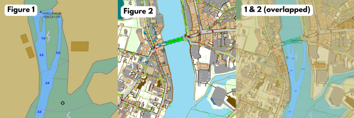
The Army Corps is in charge of dredging a portion of the river near downtown to increase usability for commercial and recreational boats. The project will dredge the two northern channels between Jesup Green and the restaurant Arezzo that can be viewed from the Ruth Steinkraus-Cohen bridge. The dredging will remove sediment buildup that currently makes this area too shallow for boats to enter at a depth of only one to three feet (see graphic figures 1 and 2).
“Moving that sediment from the river to Long Island Sound is a mechanical function of the dredging barge. So there’s not a lot of consideration about mixing freshwater or saltwater,” said Director of Public Works and DPIC committee member Peter Ratkiewich. “We [the DPIC] would like to see navigability between the two downtowns in Westport. That channel between the two could have riverine transportation in between.”
After extraction, a barge transports the material out to the middle of the Long Island Sound where it is dropped into a large underwater pit. But before the project begins, multiple rounds of testing must be completed to determine where the extracts can go due to potential contaminants. This process has been halted multiple times due to timing.
This project has faced repeated setbacks due to geographical testing complications and pushback from the community over environmental concerns.
“They [the Army Corps] have tested it probably at least three times in the last 20 years,” said Ratkiewich. “They said, well, the project hasn’t gone anywhere, and there’s too long between the last testing and now, so we have to retest because we’re not sure of what came down the river in the last 10 years.”
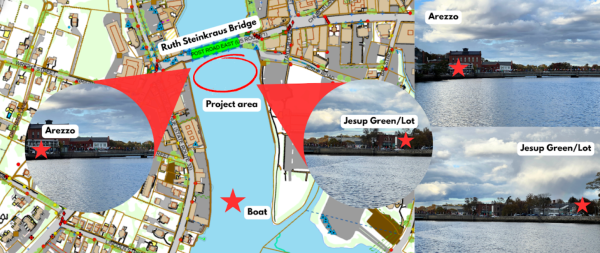
(Screenshot from Town of Westport AxisGIS website, photos and graphic by Kasey Feeley ’26)
The RTM previously reversed two environmental rulings for the dredging project intended to be a part of the failed Hamlet at Saugatuck development after pushback from local groups such as the Westport Alliance for Saugatuck (WAS).
In an opinion submitted to the Westport Journal by Westporter Dara Lamb on behalf of WAS the rulings were called “rushed” and the list of concerns included “potential for contaminated groundwater flow into the Saugatuck River, harbor and Long Island Sound, … negative impacts on wildlife, biodiversity, and residents’ quality of life and property values due to light and noise pollution.” These same concerns apply to this project.
While the project is expected to take a few months, the contents of the sediment can often be unpredictable and slow the process even more. During a recent dredging southward near Saugatuck Rowing Club in February, they found 30 cubic yards of clamshells. The difficulty in digging up clamshells was said to be equivalent to digging up solid concrete, according to Erik Hansen of Hansen Marine Contractors who was in charge of the project.
One of the key benefits of the project is reduced flood risks for downtown areas, including the waterfront parking lots. The goal of upgrading the riverside parking lots is to increase accessibility and aesthetics while also improving drainage systems to prevent flood damages.
“The goal of the project is to take and reconnect to the riverfront. That’s the name of the project,” said Ratkiewich. “Downtown is all around the riverfront, and yet all we do is park next to it.”
Parker Harding will receive upgrades such as a public park area, boardwalk, and improved landscaping. Parker Harding is a flood risk area due to its proximity to the river; therefore, drainage and utilities intended to manage flood waters will also be updated.
As for Jesup Green, plans posted to the DPIC website conceptualize two options: option A: “The Weave” or B: “The Links.” Both are intended to achieve similar goals including keeping the existing stairs and rainbow crosswalk, with some new additions such as an outdoor classroom, children’s play area, and more outdoor seating opportunities.
Jesup Green and the Imperial lot will ultimately be tied by these plans surrounding the library; upgrades to Imperial aim to encourage usage by Levitt Pavilion guests and others visiting downtown. One of these features is a new bridge to the upper library parking lot. The Imperial lot upgrades will include a new structure with public restrooms and connected storage for the farmers market, native plants along the waterfront, an overlook with seating, water access and a kayak launch.
While the start date is unclear, the project is expected to be completed within a few months.

John Bolton • Dec 1, 2025 at 1:49 pm
Kasey — fantastic job. You took a really dense topic and made it surprisingly easy to follow. Speaking just for myself (not for P&Z), and without pre-deciding anything that may come before me, hat tip — this is the kind of clear reporting that helps the whole town understand what’s going on. Keep going. Westport needs more of this.